Hop Picking Pictures and Notes from John Godfrey

Some Pictures and Notes from John Godfrey

Probably taken in the late 1940’s, at Wakely’s hop garden, near Hartlip Hill. The lady rear left is Mrs. Tutt, who lived at 38 Ivy Street in Rainham. On her left is her eldest daughter Ivy Coleman, to her left is her daughter Pamela. They lived at 38 Asquith Road in Wigmore. The ‘herbert’ on the left is John Godfrey, who lived at 330 Maidstone Road. In September 1955 Pamela and John were married in St Margaret’s parish church in Rainham.
Mrs. Tutt, who lived at 38 Ivy Street in Rainham

This too was taken at Wakely’s in about 1945. On the left, a younger Pamela Coleman is busy ‘scratching them off’. In the centre Daisy Roper, daughter of Mrs. Tutt (above) nurses her daughter Eileen. The identity of the young lady on the right remains a mystery.


A photograph of St Margaret’s, in Maidstone Road, Wigmore. This was the first photograph that I took on a Kodak 127 camera and processed the film. I guess it was taken in the summer of 1946 when we lived at the bungalow opposite St Margaret’s, No.330. I understand that prior to the outbreak of WWII, St Margaret’s had been a tearoom. The post to the right of the picture perhaps advertised the fact, I cannot remember. However I do remember them selling fresh produce during the summer months, including some very tasty tomatoes. The grounds extended to the then border of the church path.

St Margaret’s, in Maidstone Road, Wigmore

The Ever Changing Face of Rainham

The Ever Changing Face of Rainham: Rainham Mark, Belisha Beacon, Hop and Vine pub, Rainham Kent Photos

Change in our Environment is a constant and continual process. Even in the short time that this site has been running many changes have been seen. An example is from some shots taken in Rainham Mark in 2003 for use with the Time Machine pages. Since they were taken the Hop & Vine has been refurbished, the petrol station, Post Office and newsagents have closed.

This area is a perfect example of how change in the urban environment is a never ending process. Since the article originally written in 2005 the area has changed further. As of November 2010 the Hop and Vine pub has closed down and the site of the former Shell/Texaco petrol station remains derelict despite various attempts to obtain planning permission for alternative uses. The former Rainham Mark post office remains empty and the newsagent has now been converted to an Osteopath surgery.

hop vine pub rainham mark belisha beacon

December 2010 - Hop and Vine pub Rainham Mark, now boarded up with former Rainham Mark post office and Shell/Texaco petrol station in distance

Jonathan Lawson, managing director at pub chain Greene King, confirmed it no longer owned the Hop & Vine building. He said: "We can confirm that the Hop & Vine has been sold to London-based development company Zaan. "Community pubs are very much at the heart of our business. Sadly, the Hop & Vine is restricted by its size and therefore has limited development potential as a pub. "After careful consideration, we reluctantly concluded that it is in the best interests of the community to accept an offer for the premises. "We would like to reassure the people of Rainham that we are committed to the area and continue to welcome customers at our nearest local pub, The Cricketers on the High Street."

The Hop and Vine was originally known as the Belisha Beacon pub. More info about the origins of Rainham Mark can be found on the website below

http://www.medwaymemories.co.uk/men_of_kent.htm


Rainham Mark post office, Shell Garage

2003

Hop & Vine pub in foreground, Rainham Mark Post Office, Newsagents and Texaco petrol station in background. This was previously a Shell garage and changed hands in the late 1990s. Note post box in front of Rainham Mark post office.

Hop and Vine Rainham 2005

2005

Hop & Vine pub in foreground, Rainham Mark Post Office now closed and post box removed, Newsagents closed and has become Osteopath surgery. The Texaco petrol station in background has now closed and the former Shell garage colours can be seen on the roofline.

hop and vine rainham closed down

2010

Hop & Vine pub in foreground has now closed, former Rainham Mark Post Office remains empty. The Osteopath surgery is now the only remaining occupied shop in this block. Further along Sophisticuts hairdressers remains open.

Jezreel's Tower, Gillingham, Kent

The Story of Jezreel's Tower, Watling Street/Canterbury Street in Gillingham, Kent

Picture postcard view of Jezreel's Tower, Gillingham also known as Jezreel's Folly. The tower was built along Watling Street (A2) at Gillingham and the bus stop there is still named after the tower. You can find out more about the Jezreel's Tower here


Interior view of Jezreels Tower

This structure, started in 1886 was the home of the Jezreelite sect (founded in 1875 by James White or Jezreel) remained unfinished and was demolished in 1961. Photo from Medway Council. (Couchman collection DE402, Medway Council)

Photo of Jezreels Tower Gillingham 1905

Photo from Martin Smith.

LCP Autoparts on Canterbury Street

One of the remaining Jezreel's buildings at the top of Canterbury Street, Gillingham was demolished in 2008. LCP Autoparts occupied the building that was previously the Jezreel's Hall on Canterbury Street. The site remains empty as of 2017.

Below you can see the similarity of the brickwork at the top of the roofline compared to the original tower. Photo from Mark at Medway Lines of Jezreels building LCP Autoparts Canterbury Street Gillingham.

Jezreels building LCP Autoparts Canterbury Street Gillingham

This is an article about the Jezreels Tower printed c1920 in the Chatham Rochester and Gillingham News, the local paper of the time. Unfortunately the paper is quite faded so it not possible to easily convert to text using OCR but these are high quality scans on the pages. Click on each section to view a high resolution version.
Article about Jezreel's Tower Gillingham Kent c1920Article about Jezreel's Tower Gillingham Kent c1920

Map to show location of site of Jezreels Tower in Gillingham

Savacentre/Hempstead Valley Shopping Centre 30th Anniversary

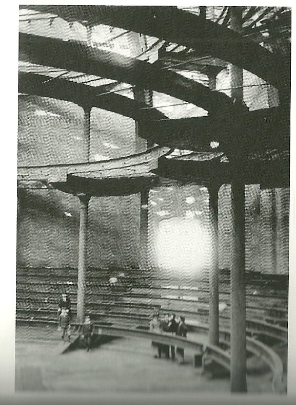
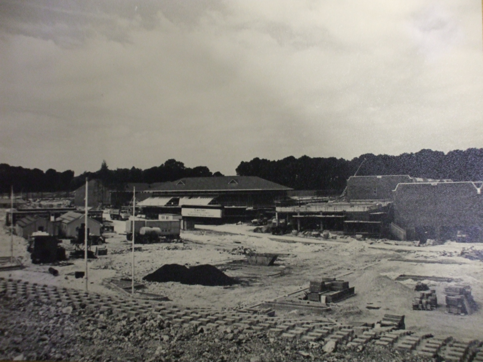
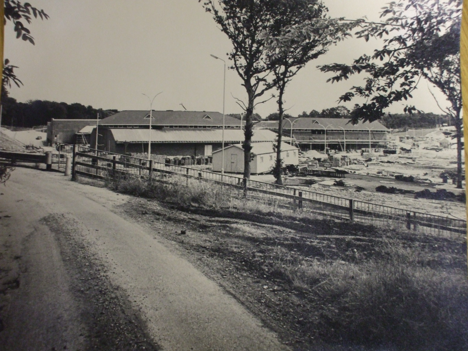
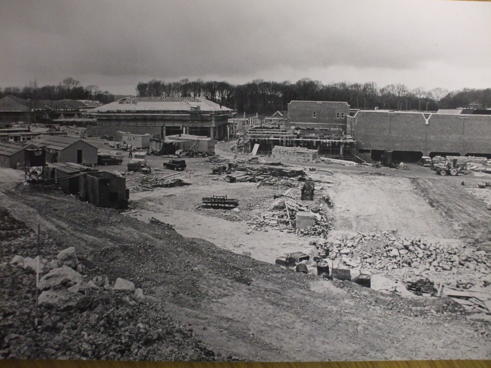
Hempstead Valley Shopping centre (aka Savacentre) near Gillingham Kent was constructed in the late 1970s just outside the village of Hempstead. It opened on 17th October 1978 so has celebrated its 30th Anniversary in 2008. These photos showing the construction of Hempstead Valley were kindly sent by Chris Shade. You can see the large sign showing the original name of Savacentre. A current photo of Savacentre is shown on the Hempstead Valley website

There is currently (2010) a proposal to redevelop the Hempstead Valley shopping centre to modernise areas of it. You can view the proposal on the Hempstead Valley website here When it is completed in 2015 it will make a huge difference to the appeal of the centre as a shopping destination.

What may seem commonplace now was groundbreaking in 1978 as there were very few other out of town shopping centres of this size at the time. Hempstead Valley was the second Savacentre (Washington Tyne & Wear opened in 1977). At the time of opening Savacentre was one of the largest out of town shopping centres in the South East. The original Picnic Parlour was the first Food Court in the UK. You can see more info about Sainsburys Savacentre here

When originally opened the main shop was Sainsburys Savacentre, the brand they originally created for their large hypermarkets. At the time Sainsburys was by far the largest supermarket in the UK with Tesco trailing far behind – a far cry from the current situation with Tesco leading the field. The originally Hempstead Valley offered 250,000 square feet of shopping space but when the centre was redeveloped in the early 1990s with an extension and new shops like M&S being added, this was increased to 330,000 square feet.

The challenge is to remember all the original shops that were there when the centre opens….Sainsburys, Presto (which then became Safeway) - but which others?
So far the following shops have been suggested for the original opening

NSS (Newsagents) then became Forbuoys
Our Price
Post Office (not one of the original shops)
Sainsburys Savacentre
Boots
Thomas Cook
Presto Supermarket
Wimpy Burger Bar
Spud-U-Like

Later additions when the extension was added in early 1990s were WHSmith, Marks & Spencer.

Notice in the aerial shot the area to the bottom right which was developed for large housing estates shortly after the shot was taken.

Photos on this page are clickable to view higher resolution versions.

Savacentre, Photos of Hempstead Valley Shopping Centre 1978:Looking towards Savacentre Hempstead Valley from roundabout 
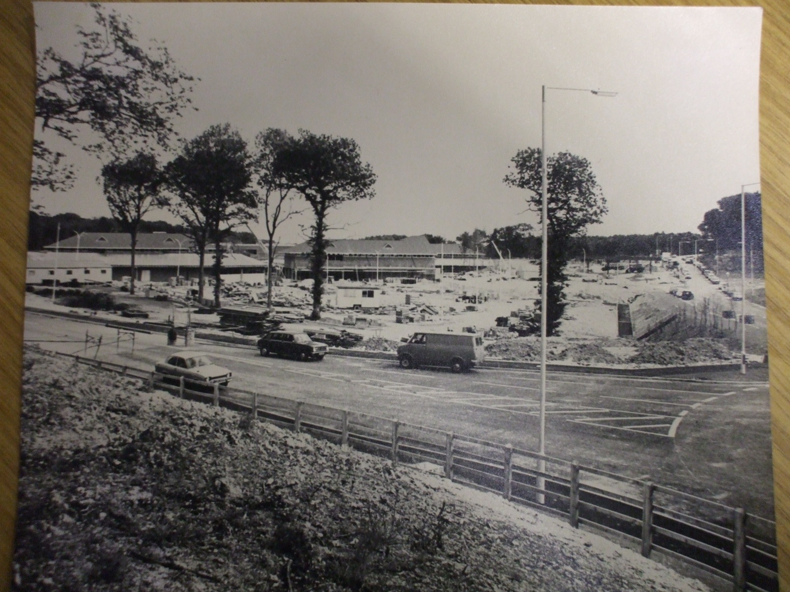
Above: Looking towards Savacentre Hempstead Valley from roundabout. Petrol station would be to middle right of photo

Photos of Savacentre Hempstead Valley Shopping Centre 1978:Looking towards Hempstead Valley from Sharsted Way

Above: Looking towards Hempstead Valley from Sharsted Way, Underground car park to right of shot, Abbey to left of shot

Photos of Hempstead Valley Savacentre 1978

Above: Looking towards Hempstead Valley from roundabout. Petrol station would be to middle right of photo

Photos of Hempstead Valley Shopping Centre 1978: Looking towards Hempstead Valley from Sharsted Way

Above: Looking towards Hempstead Valley from Sharsted Way. Underground car park to right of shot, Abbey to left of shot

Aerial photo of Hempstead Valley Savacentre 1978

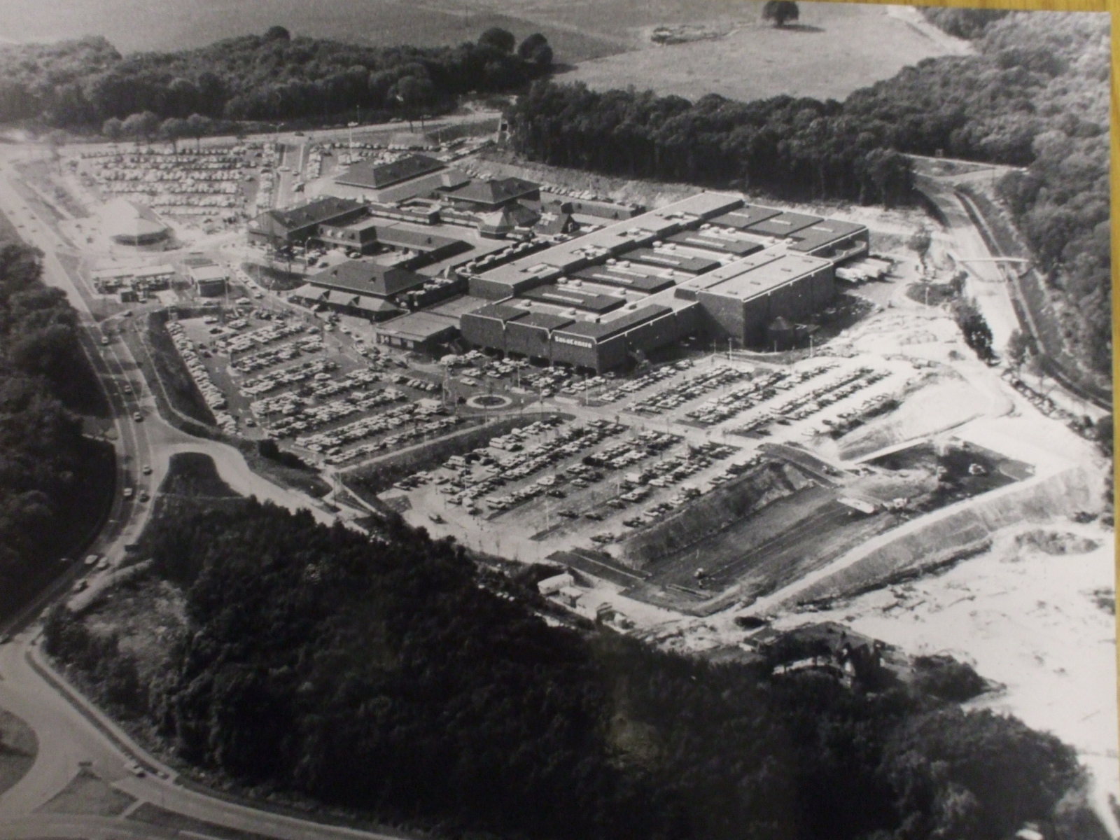
Above: Aerial photo of Hempstead Valley Savacentre 1980. Sharsted Way runs along left hand side of photo

Subcategories

Action Forum is a free monthly magazine that is distributed to the Rainham area covering Wigmore, Parkwood and Hempstead as well. This archive covers old copies of the magazine dating back to its initial publication in 1969 and give a fascinating glimpse into life in Rainham over the last 50 years.

Link to Article Index - Action Forum Index - Photos and Articles from 1969 onwards

Historical tales

Local Events

Photos

Rainham Life

Free Joomla! templates by AgeThemes