Rainham History - Old Photos & Memories of Rainham Kent
Old Photos and Articles about Rainham Kent
  • Home
  • Latest Articles Added
  • All Articles
  • Search the site
  • Photos of Rainham
    • Rainham Then and Now
    • Time Machine
    • Rainham Streets
  • Articles about Rainham
  • Action Forum Magazine
  • News
    • Local Events
    • Help Wanted
  • About Site
    • Links
    • Blog

Bumbles Wine Bar - Rainham Kent 1982

This photo of Bumbles wine bar was taken in November 1982. The sign in the window reads "Bumbles Open Thursday 18th Nov at 7pm" so presumably the photo was taken to advertise the opening of the wine bar on that date. Bumbles wine bar was located on Rainham High Street almost opposite Pudding Road. The wine bar was owned by James Field. The building is now PHC Homecare appliance repair shop.

Apparently the building was Fred's Cafe in the 1960s with many people having fond memories of visiting for strong cups of tea. By 1990 the building had become an Indian restaurant so Bumbles Wine bar was open less than 8 years. Fred's Cafe in Rainham is listed in the 1951 High Street traders at 126 High Street.

Bumbles wine bar was located on Rainham High Street almost opposite Pudding Road

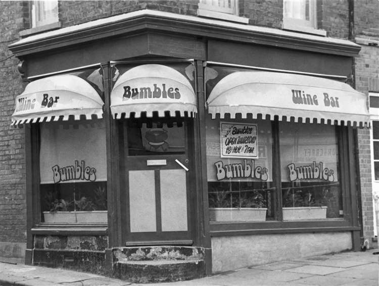
I can't really recall this wine bar existing in Rainham when I was a teenager so assume it wasn't open for very long.

The photo below shows the PHC service centre in 2001. You can see the step is the same as the Bumbles wine bar photo above.

Bumbles wine bar was located on Rainham High Street previously Fred's cafe in the 1960s

Details
Category: Photos
  • rainham old photos,
  • rainham high street
  • 1980s

Channel Tunnel Rail Link

Channel Tunnel Rail Link bridge across River Medway

Although not directly affecting Rainham as the line passes some miles away, these images give a good impression of the impact of the CTRL line on the Kentish landscape of Channel Tunnel Rail Link bridge across River Medway. This also shows the construction of the new motorway bridge built to expand the M2 motorway to four lanes each direction across the River Medway which widened the motorway between junctions 1 and 4 in early 2003.

Medway Bridges, 2002

  • Click to enlarge image M2-ChannelTunnel-RailLink_01.JPG
  • Click to enlarge image M2-ChannelTunnel-RailLink_02.JPG
  • Click to enlarge image M2-ChannelTunnel-RailLink_03.JPG
  • Click to enlarge image M2-ChannelTunnel-RailLink_04.JPG
  • Click to enlarge image M2-ChannelTunnel-RailLink_05.JPG
  • Click to enlarge image M2-ChannelTunnel-RailLink_06.JPG
  • Click to enlarge image M2-ChannelTunnel-RailLink_07.JPG
  • Click to enlarge image M2-ChannelTunnel-RailLink_08.JPG
  • Click to enlarge image M2-Widening-Bluebell-Hill66.JPG
  • Click to enlarge image M2-Widening-Bluebell-Hill67.JPG
  • Click to enlarge image M2-Widening-Bluebell-Hill68.JPG
  • Click to enlarge image M2-Widening-Bluebell-Hill69.JPG
  • Click to enlarge image M2-Widening-Bluebell-Hill70.JPG
  • Click to enlarge image M2-Widening-Bluebell-Hill71.JPG
  • Click to enlarge image M2-Widening-Bluebell-Hill72.JPG
  • Click to enlarge image M2-Widening-Bluebell-Hill73.JPG
  • Click to enlarge image M2-Widening-Bluebell-Hill74.JPG
  • Click to enlarge image M2-Widening-Bluebell-Hill75.JPG
  • Click to enlarge image M2-Widening-Bluebell-Hill76.JPG
  • Click to enlarge image M2-Widening-Bluebell-Hill77.JPG
  • Click to enlarge image M2-Widening-Bluebell-Hill78.JPG
  • Click to enlarge image M2-Widening-Bluebell-Hill79.JPG
  • Click to enlarge image M2-Widening-Bluebell-Hill80.JPG
  • Click to enlarge image M2-Widening-Bluebell-Hill81.JPG
  • Click to enlarge image M2-Widening-Bluebell-Hill82.JPG
  • Click to enlarge image M2-Widening-Bluebell-Hill83.JPG
  • Click to enlarge image M2-Widening-Bluebell-Hill84.JPG
  • Click to enlarge image M2-Widening-Bluebell-Hill85.JPG
  • Click to enlarge image M2-Widening-Bluebell-Hill86.JPG
  • Click to enlarge image M2-Widening-Bluebell-Hill87.JPG
  • Click to enlarge image M2-Widening-Bluebell-Hill88.JPG
  • Click to enlarge image M2-Widening-Bluebell-Hill89.JPG
  • Click to enlarge image M2-Widening-Bluebell-Hill90.JPG
  • Click to enlarge image M2-Widening-Bluebell-Hill91.JPG
  • Click to enlarge image M2-Widening-Bluebell-Hill92.JPG
  • Click to enlarge image M2-Widening-Bluebell-Hill93.JPG
  • Click to enlarge image M2-Widening-Bluebell-Hill94.JPG
  • Click to enlarge image M2-Widening-Bluebell-Hill95.JPG
  • Click to enlarge image M2-Widening-Bluebell-Hill96.JPG
  • Click to enlarge image M2-Widening-MedwayBridge100.JPG
  • Click to enlarge image M2-Widening-MedwayBridge101.JPG
  • Click to enlarge image M2-Widening-MedwayBridge102.JPG
  • Click to enlarge image M2-Widening-MedwayBridge103.JPG
  • Click to enlarge image M2-Widening-MedwayBridge104.JPG
  • Click to enlarge image M2-Widening-MedwayBridge105.JPG
  • Click to enlarge image M2-Widening-MedwayBridge106.JPG
  • Click to enlarge image M2-Widening-MedwayBridge107.JPG
  • Click to enlarge image M2-Widening-MedwayBridge108.JPG
  • Click to enlarge image M2-Widening-MedwayBridge109.JPG
  • Click to enlarge image M2-Widening-MedwayBridge97.JPG
  • Click to enlarge image M2-Widening-MedwayBridge98.JPG
  • Click to enlarge image M2-Widening-MedwayBridge99.JPG
  •  

Details
Category: Photos

Chestnuts High Street Rainham Kent

This photo of Chestnuts on High Street Rainham was kindly provided by Michael Ball who writes "My grandmother, and sisters were born in Popes Hall in Hartlip and eventually moved to Canada. I have a fairly extensive collection of Wakeley and Rainham pictures which I have added to my family history collection. I am attaching an early picture of what I believe is "The Chestnuts" on the High Street in Rainham. I believe that it was the home of one of the members of the Wakeley family at one time."
 
This impressive building was demolished to make way for housing in Rainham.
 
Chestnuts High Street Rainham Kent
 
It was reported for the 1887 Jubilee celebrations for Queen Victoria that "At The Chestnuts, a house owned by local preacher and businessman Thomas Stanley Wakeley, the colours of the barge ‘Richmond’ surmounted the building accompanied by a transparency of the crown surrounded by flags."
Details
Category: Photos

Church School Demolition 1977 (Station Road now Rainham Shopping Centre)

St Margaret's Church School was located at the top of Station Road Rainham. The school moved from the building in the late 1960s and for a short time it was used as RWCA Community centre (Rainham & Wigmore Community Association) until the current building at Station Oasts was completed in the late 1970s. You can read about the History of the National School/Church School in Station Road Rainham here.

This photo of Church School at the top of Station Road Rainham Kent dates from around 1900 with Ye Old White Horse pub on right hand side of photo. 

Church School Station Road Rainham Kent 1900

The Church school was demolished in 1977 to make way for the development of Rainham Shopping Centre next to Barclays Bank (now Greedy Banker bar/pub in 2025). These photos of the demolition were kindly provided by Fred Moore and were taken from the building opposite above the Co-op that was occupied by Flaherty Brothers in the 1970s and 1980s.

Below: Photo taken looking West showing the rear of houses in Holding Street. To the left is the rear of High Street buildings. You can still see the steps of the school that were added after the 1900 photo above was taken.

Church School Rainham demolition 1977 Station Road

Below: Photo taken looking South showing the rear of High Street buildings including to the far left what was the Barclays Bank building at the time .

Church School Rainham demolition 1977 Station Road

Below: Looking West again towards the rear of houses in Holding Street with the new houses of Suffolk Avenue in front of them. To the right at number 3 Station Road you can see the sign advertising Kemsley's Family Butchers selling Cooked Meats and Pies

Church School Rainham demolition 1977 Station Road

Below: The montage below combines all 3 of the above photos to show the full panorama of the area of the school along with the other land that was being developed for Rainham Shopping Centre.

Church School Rainham demolition 1977 Station Road

Details
Category: Photos
  • rainham old photos,
  • station road
  • church school

Copsey Butchers Station Road Rainham Kent c1910

Copsey Butchers were located at 78 Station Road Rainham Kent. This photo is undated but was taken pre 1930 as the original Cricketer's pub is still there. From the atire and streets it would appear to be around 1910.

The London Central Meat Company shop with the sign Prime OX Beef is on the corner of Hothfield Road and Station Road and is still the same look although currently brightly painted and as of 2024 occupied by Redbook accountants

 Copsey Butchers Station Road Rainham


Details
Category: Photos
  • rainham old photos,
  • station road rainham
  • 1910 old photo
  1. Crest Packaging Water Ball 1993 (now Tesco Extra)
  2. E Nicholson Sweet Shop Rainham Kent
  3. Edwin Road Events in 1930s
  4. Farm Shop & Bayswater High Street Rainham 1987

Subcategories

Rainham Roads Article Count:  28

Roads around the Rainham - old photos of how roads used to look in days gone by

Rainham People Article Count:  34

Decades - Old Photos Article Count:  9

Old photos by decade

Page 1 of 4

  • 1
  • 2
  • 3
  • 4

Most Read Pages

  • Dene Holes found in Rainham, Kent
  • Rainham School for Girls
  • Savacentre/Hempstead Valley Shopping Centre Construction Photos
  • Old Photographs of Rainham, Kent - 1950s
  • Growing up in Rainham in the 1940s