
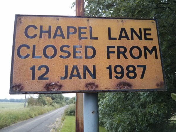
For years I've noticed a sign on a dead end road as a drive out of Hempstead so I finally stopped and got a few photos. This was a road that I remember driving down when I was learning to drive and shortly afterwards was closed. I've not found any information why Chapel Lane in Hempstead was closed to traffic in 1987 but the road remains in place with just a gate blocking the entry.
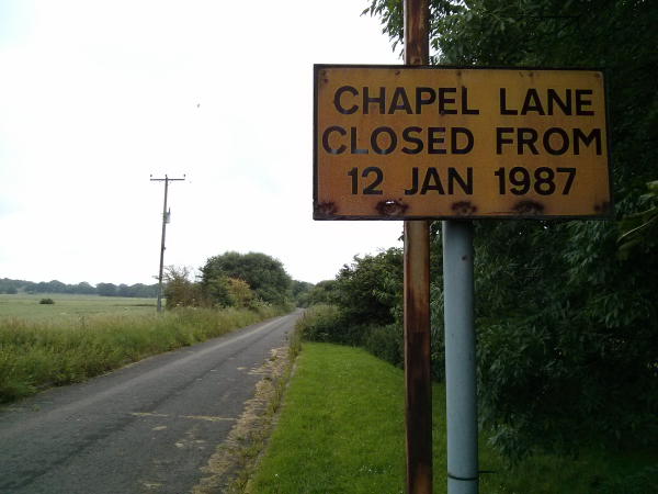
Chapel Lane Hempstead runs from Forge Lane (which leads to Bredhurst) near the junction with Lidsing Road through Chapel Hill Woods and joins Hempstead Valley drive near Savacentre/Hempstead Valley shopping centre M&S entrance. The road is still shown on Google maps with no indication of its closure. The road is narrow and maybe was unsuitable for large numbers of vehicles but would ease traffic on the Capstone Road/Hempstead Road junctions.

Some more information about Chapel Lane and the Chapel of St Mary Magdalene, Lydsing is here http://www.ghostconnections.com/Medway%20Recce.htm


")


")
")
")


")


")


")


")


Comments
Regards
Also in the 1980s there were plans to link Walderslade Woods Road and Sharsted Way as an alternate southern Medway by-pass running alongside the M2 for use by local traffic. This idea was later abandoned I believe around the time Medway became a Unitary Authority as most of this road would have laid outside the UA's boundaries and would have been down to Kent County Council's duty to maintain.
i would love to be able to meet someone here and go thorough where things was etc and the grave yard my home number is 01634 315333, 07847376990
Brian.
Our next location was on the rural side of Hempstead. Hempstead village was once further north than it is now and immediately adjoining this was, and still is, the parish of Lidsing. Now only a few houses and The Harrow public house there are few signs that a reasonable sized settlement once stood here. Chapel Lane was closed to through traffic in January 1987 (as the sign still proudly states at one end) when the M2 was widened. The northern end was blocked off where it joins Hempstead Valley Drive which did not exist previously. At a sharp bend on Chapel Lane once stood the Chapel of St Mary Magdalene, Lydsing.
The chapel is first referred to in the Textus Roffensis, a document recording the fees of various churches payable for Chrism fees. This document was first prepared around 1080 when it was attended by the curate of Gillingham. By the 12th Century it was associated with the Nunnery of St Sexburgha at Minster on Sheppey and three hundred years later with St Andrew's Priory (now the Cathedral) at Rochester.
In 1798 Edward Hasted writes 'At this hamlet of Lydsing there has been of long time, and is now, a chapel of ease to the parish of Gillingham; in it divine service continues to be performed once a month, though there are but six houses within this district. The chancel, or east end of this chapel, was rebuilt a few years since with brick at the expence of the late vicar Mr. Jenkinson. It is endowed with all the tithes of this hamlet, and was valued in the year 1650, in a survey then taken by order of the ruling powers, at 251. per annum.'
Restored around this time it gradually fell into disrepair again and a faculty was drawn up to demolish the chapel in 1881 and use some its building materials in the repair of the graveyard walls. In 1903 Lidsing became part of the parish of Gillingham.
The tell tale signs of any demolished church site can include the obligatory yew tree, uneven ground in the churchyard even if no markers exist and some remains of walls or boundaries to the churchyard.
Immediately upon entering the woods here we found ourselves climbing from an even piece of ground up a distinct flint embedded earthwork. When we traced this we found it to be square in appearance with even raised flint earthworks on 3 sides, the missing side being where Chapel Lane runs parallel to the site. Progressing west from here the ground evened out but with a distinct uneven area by some older trees – maybe a burial. Within the newer trees we saw one of our other signs, a grand tall yew tree stretching into the canopy.
Finding our way to the yew we found ourselves at the furthest west end of the site. Glancing around the area east from here towards the enclosure there was a larger amount of flint debris, bricks and tiles. There was an absence of walls or footings but surely here was the site of the Chapel Of St Mary Magdalene. With further consultation on the 1879 map the area can be firmly identified
RSS feed for comments to this post